

Online tools & databases
This is the gateway to Ecology's many web-accessible databases and tools. These tools help you conduct business with us, and give you access to a wealth of scientific data and information.
Featured online tool
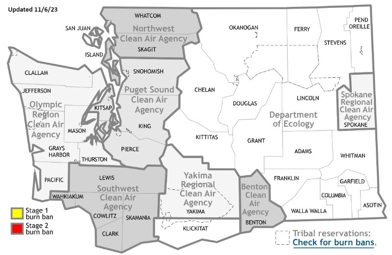
Current air quality burn bans
The map and table show burn bans called by Ecology. It also shows other burn bans we know about.
Before you burn, check with your local clean air agency by clicking on your county on the map.
 Alert – Fake links to SecureAccess Washington (SAW) from search engines are being reported. For more information, see our
 Air & Climate
- Air monitoring network – current air quality conditions from air monitoring stations that measure air pollution across Washington.
Water & Shorelines
- Flood hazard maps – do you live or work in a floodplain? Flood hazard maps help determine the flood risk to your home or business.
- Lake data map – see data, including toxic algae, from state lakes where we do monitoring.
- Public beaches (Coastal Atlas) – maps and information about public beaches in Washington state.
- Shoreline aerial photos – current and historical photos of coastal, sound and inland shorelines.
- Swimming beach closures (Coastal Atlas) – maps and information about beach closures in and around Puget Sound and Washington's ocean beaches.
- Water Quality Atlas – maps and information about the state's lakes, rivers, streams, and estuaries.
- Well report viewer – information on the location, ownership, construction details, and lithology of completed wells.
Waste & Toxics
- Recycling services – information on recycling opportunities in your neighborhood.
Cleanup & Spills
- Contaminated sites – we have a couple of ways you can learn more about polluted properties we're cleaning up:
- What's In My Neighborhood – our interactive mapping tool.
- Cleanup and Tank Search – search by for cleanup sites and underground storage tanks by location, status, contaminant, or other features.
- Dirt Alert map – shows the general pattern of arsenic contamination from the Asarco Tacoma Smelter. You can also view information about other areas of arsenic contamination statewide.
- Spills map – an interactive map showing the estimated crude oil movement by rail in Washington.
Doing business with Ecology
- Ecology Administration of Grants and Loans (EAGL) map – see projects funded by Ecology grants and loans.
- State Environmental Policy Act (SEPA) Register – SEPA and NEPA documents posted by the Department of Ecology since 2000.
- Staff directory – Ecology staff e-mail addresses and phone numbers.
- Subject referral directory – look up staff by subject or topic.
Public tools
- Air Permit Search – find final Prevention of Significant Deterioration (PSD) permits and air operating permits (AOP).
- EcoEPay – we accept online payments for some permits and fees. Use this tool to make a payment.
- Facility/Site database – access information on facilities and sites of interest to Ecology.
- Hazardous waste facilities in Washington State search tool – use this tool to access public records from regulated dangerous waste sites in Washington. This data comes from TurboWaste, Washington’s dangerous waste reporting tool.
- Plastic producer registration and reporting – includes guidance to help producers comply with the new Postconsumer Recycled Content for Plastic Containers rule (Chapter 173-925 WAC).
- Polluted waters - 303(d) Listing – listing of streams, lakes, and estuaries whose beneficial uses are impaired by pollutants.
- Water quality permit databases – information on water quality permits for municipalities, industries, dairies, fish-rearing facilities, stormwater, sand and gravel operations, and aquatic pesticides.
- Water rights search – records can be searched by: location, document/record number, name of the person to whom the water right was issued, or name of the claimant, if it is a water right claim.
Secure tools requiring log-in
- Advance Notice of Oil Transfer – use this tool to submit advance notice of transfer (ANT) by web-based form to satisfy both Ecology and United States Coast Guard (USCG) reporting requirements for the advance notice of oil transfer.
- Aquatic Noxious Weed NPDES Permit – database is administered by the WA Department of Agriculture for permit coverages to control noxious weeds using chemicals when there might be an indirect discharge to nearby surface water.
- Children’s Safe Products Act reporting database – login for manufacturers to submit required data
- Discharge Monitoring Reports (DMRs) – facilities with an National Pollutant Discharge Elimination System (NPDES) or State Waste Discharge permit are required to monitor the discharge from their facilities and to submit reports to us about this discharge. (Log-in required)
- E-Cycle electronic product recycling collector registration – register as a collector to participate in E-cycle Washington.
- Solid waste facility forms – access to online reporting, as well as solid waste reporting forms, facility checklists, permit deferral applications and notifications.
- TurboWaste – electronic reporting system used to submit Dangerous Waste Annual Reports and updated notifications.
- Water quality permitting portal (WQWebPortal) – submit your discharge monitoring reports (DMR) online.
- Water use reporting – review your metering account and submit your metering data.
- Well construction – we have a variety of online tools for well drillers to help with licensing and reporting.
- Well Report Gateway – login to submit a well report to our database.
See more regulatory online tools – go to our Regulations & Permits collection and select "Online Tools" in the Category filter on the left.
- Air quality monitoring — this database provides near real-time air quality information to protect health. It's used to determine if air quality meets health-based federal standards.
- Environmental Information Management (EIM) — access discrete and time-series environmental data for air, water, soil, sediment, aquatic animals, and plants.
- Geographic Information Systems (GIS) data — description
- Lake environmental data — Washington state lake data includes: aquatic plants, toxic algae, herbicide use, and fish management.
- Long-term marine water quality data — information from all saltwater sampling since 1989.
- Marine sediment data - we measure levels of chemicals & toxicity, and identifying invertebrates in Puget Sound sediments.
- Product testing database — various consumer products are tested to ensure state and federal rules are met. The presence of a chemical in a product does not necessarily mean it's unsafe. See the focus sheet ror more information.
- Freshwater DataStream: Flow Monitoring Network — Map-based application for continuous freshwater data, including nearly real-time information on streamflow and water quality.
- Freshwater Information Network (FIN) — searchable river and stream data from Environmental Information Management (EIM)
See more scientific online tools — Go to our Research & Data collection and select "Online Tools" in the Category filter on the left.
The following apps are available for download to your mobile device:
- Air Quality WA – air-monitoring network to accurately measure air pollution and meteorology conditions around the state
- Pump out, don't dump out – See the Puget Sound No Discharge Zone boundary; find the closest pumpout, dump station, or restroom to any location.