

Reducing regional haze in scenic areas
We're working to improve visibility in national parks and wilderness areas. We monitor air quality and develop strategies for returning visibility to natural conditions by 2064. Our initial strategies focus on large industrial sources of air pollution and how forest debris is burned.
Measurements show that visibility at Washington's scenic areas has improved over the past two decades.
Regional haze ruins our view
Have you ever looked out expecting to see a breathtaking view of Mount Rainier or the North Cascades, and been disappointed to see an ugly brown or white haze ruining the view? It's called "regional haze" and it's air pollution. Regional haze has reduced scenic views in national parks and wilderness areas from an average of 140 miles down to 35-90 miles in the Western U.S. In the Eastern U.S., visibility has decreased from an average of 90 miles down to 15-25 miles.
Haze is caused when tiny particles in the air absorb and scatter sunlight between the object we are looking at — such as Mount Rainier — and our eyes. More particles in the air means that more light is either absorbed or scattered, reducing the clarity and color of what we see.
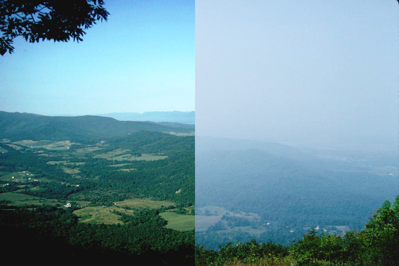
Clear view compared to regional haze (Click on the image to make it bigger.)
Sources of fine particles
The fine particles that cause haze come from both natural and human-caused sources. Natural sources include windblown dust and soot from wildfires or other burning. Human-caused sources include motor vehicles, electric utilities, industrial fuel burning, and manufacturing. Haze from these sources can come from as far away as Asia. Some of the particles that cause haze are emitted directly to the air. Others are formed from gases, such as sulfur dioxide and nitrogen dioxide, that can be carried far from their original source. This is why haze is often seen in areas that don't have any major sources of air pollution nearby.
Visibility goals
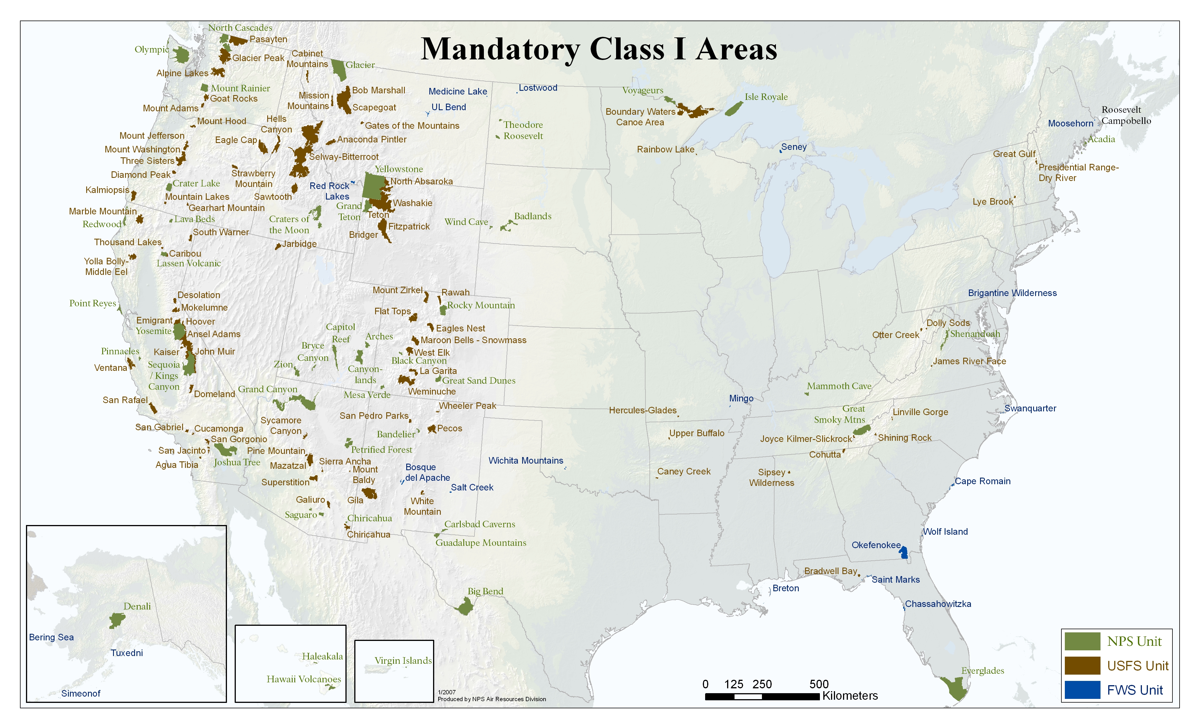
The federal Clean Air Act requires states to protect and improve visibility in national parks and wilderness areas. The goal is to return visibility in the 156 national parks and wilderness areas to natural conditions by 2064. These are "mandatory Class 1 federal areas" where visibility is especially important. States must submit their regional haze plan to EPA about how to reduce air pollutants that affect visibility in these areas.
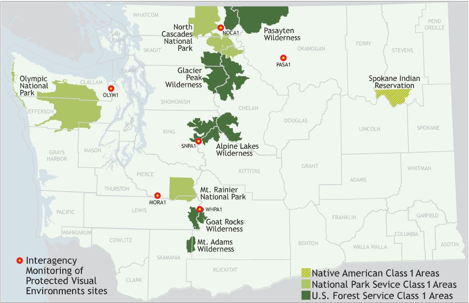
Washington's Class 1 Areas and IMPROVE Monitoring Network Sites (Click on the map to make it bigger.)
Washington has eight Class 1 areas, totaling more than 3.3 million acres of land. They are:
- Alpine Lakes Wilderness
- Glacier Peak Wilderness
- Goat Rocks Wilderness
- Mt. Adams Wilderness
- Mt. Rainier National Park
- North Cascades National Park
- Olympic National Park
- Pasayten Wilderness
Measuring visibility
We partner with federal land managers — Bureau of Land Management, EPA, National Park Service, U.S. Fish and Wildlife Service, and U.S. Forest Service — to measure visibility by collecting and analyzing particles in the air. This work is part of the Interagency Monitoring of Protected Visual Environments (IMPROVE) monitoring network. In Washington, there are six IMPROVE monitoring sites. One 24-hour air sample is collected at each site every three days, providing up to 121 samples each year from each site.
We analyze the samples for sulfates, nitrates, carbon-containing particles, sea salt, and dirt and sand — all of which affect visibility. The amount and type of haze depends on:
- What the particles in the air are made of (composition).
- Particle size.
- How many particles are in the air (concentration).
We show visibility in one of three ways:
- Visual range (the number of miles the bare eye can see).
- Deciviews (the number on a visibility index where the higher the number, the worse the visibility). The human eye can see the difference in visibility of one deciview.
- A measure of light scatter using an instrument such as a nephelometer.
Long-term monitoring trends show that visibility is improving at Washington's national parks and wilderness areas.
Improving visibility
In 2010, the TransAlta power plant agreed to reduce mercury and nitrogen oxide emissions. The agreement required TransAlta to burn low sulfur coal to protect and improve visibility in national parks and wilderness areas. In 2011, the governor signed a bill requiring TransAlta to change to cleaner fuel and reduce greenhouse gas emissions. At the end of 2020, TransAlta stopped using one of two coal-fired boilers. They will stop using the second one by the end of 2025. In the meantime, they will use nitrogen oxide-reducing technology on the remaining boiler. This was a significant step to reduce regional haze.
In December 2010, we revised the Regional Haze State Implementation Plan (SIP) which covers 2005–2018. As the basis for future regional haze state implementation plans, this plan:
- Determined baseline (2000-2004) visibility conditions for Washington's mandatory Class 1 Areas.
- Developed a long-term strategy to improve visibility.
- Provided inventories of emissions causing a visibility problem.
- Analyzed natural and human-caused sources of haze for Washington's mandatory Class 1 Areas.
- Established reasonable progress goals for 2018 for Washington's mandatory Class 1 Areas.
- Determined and required upgrading emission technology (Best Available Retrofit Technology, BART) at large industrial sources.
In January 2022, we revised the Regional Haze State Implementation Plan (SIP) which covers 2018–2028 and includes a progress report for 2014–2018. This second plan:
- Establishes visibility goals for 2028 for Washington’s mandatory Class 1 federal areas.
- Develops a long-term strategy to improve visibility.
- Provides inventories of emissions causing a visibility problem.
- Analyzes natural and human-caused sources of haze in Washington’s mandatory Class 1 federal areas.
- Selects and evaluates the largest emitting stationary sources for potential emission controls.
Related links
Contact information
Philip Gent
Environmental Engineer
philip.gent@ecy.wa.gov
360-918-6922