

Marine spatial planning
The Marine Spatial Plan (MSP) for Washington’s Pacific coast is a living management process to address the complex issue of managing potential ocean uses. It contains enforceable policies and guidelines that regulate new ocean uses to help protect the coast's unique existing uses and sensitive ecological areas.
Washington’s four Pacific coastal counties — Clallam, Grays Harbor, Jefferson, and Pacific — account for 331,000 acres of marine waters and 157 miles of open ocean coastline. Coastal communities, including coastal Tribes, have a rich history and maintain a unique relationship to coastal resources. Still, there are increasing demands on these resources, including new projects and uses that can potentially create conflicts.
Ecology leads the State Ocean Caucus (SOC), an interagency team that focuses on ocean policy management. The SOC is tasked with implementing the many aspects of the MSP and to ensure Washington maintains a resilient, healthy coastal marine ecosystem. This includes supporting sustainable economic, recreational, and cultural opportunities for coastal communities, visitors, and future generations.
When does the MSP apply?
The MSP process mainly applies to "new" uses of the coastal and offshore environment — typically something that has not been previously permitted or authorized. We anticipate reviewing proposals for new activities such as:
- Ocean energy projects
- Actions requiring dredging or disposal of dredge tailings
- Installation of underwater infrastructure
- Offshore aquaculture
- Seabed mining
- Any new use that may disturb existing marine environments, habitat, or water quality
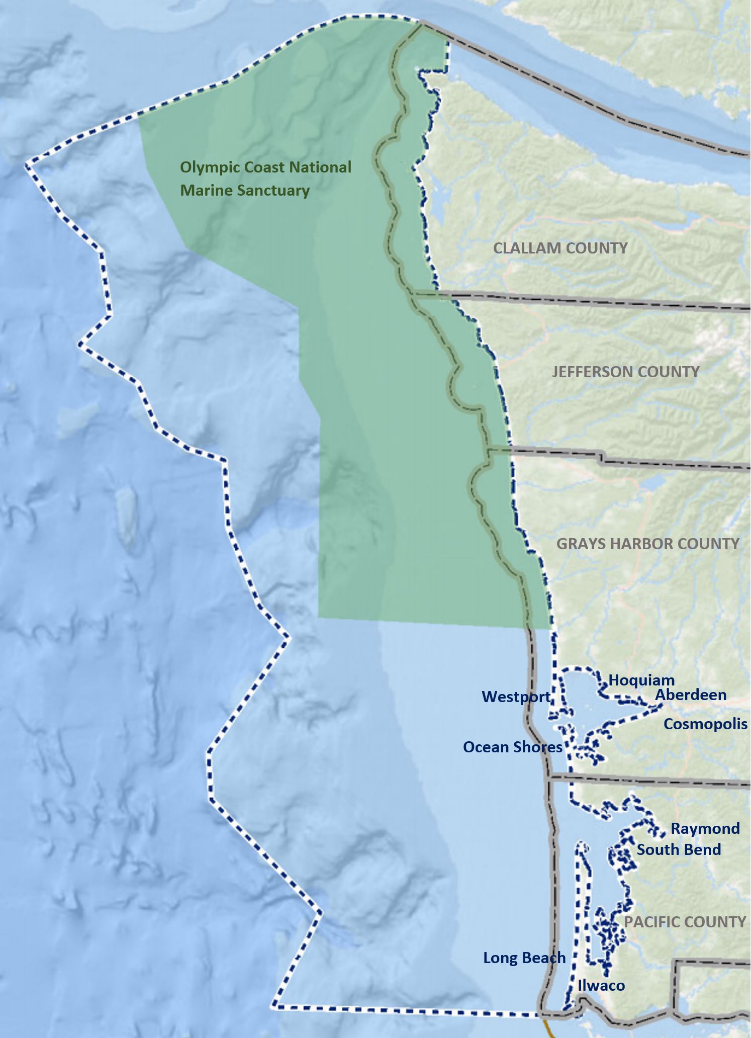
Washington's Marine Spatial Planning study area outlined in the white and blue dotted line.
Where does the MSP apply?
The MSP applies within state waters off of Washington's Pacific Ocean coast from Cape Flattery to the mouth of the Columbia River, including Grays Harbor and Willapa Bay. It does not include the Strait of Juan de Fuca or Puget Sound. The MSP study area extends to ocean waters 35-55 nautical miles offshore, up to a depth of 700 fathoms (see map for illustration). The MSP management framework applies to state waters, and the enforceable policies also apply in federal waters.
Submitting a proposal under the MSP
Before submitting permit applications for your project or proposal, we recommend you:
- Review the full Marine Spatial Plan, especially Chapter 4.
- Contact us to discuss project requirements, that may include, but are not limited to:
- Site-specific information
- Evaluation of coastal effects
- Construction and operation plans
Submitting an MSP proposal can also involve many different local, state, and federal permits or authorizations, depending on the type of use and the location of the project. During your planning process, you will need to consult with the appropriate planning and regulatory authorities and with tribal governments. Please refer to our marine spatial planning maps and data portal to help inform your planning process.
Understanding the MSP process
The Marine Spatial Plan is a living management document written to address the complex issue of managing a growing number of potential new ocean uses — a situation that is further complicated by multiple overlapping jurisdictions offshore. The MSP uses a planning strategy and a coordinated decision-making process to address this challenge and anticipate future needs. It provides a framework for state agencies and local governments to evaluate new proposed ocean uses and identifies wide-ranging data that can help inform ocean resource management decisions for various parties.
Federal consistency
The final Marine Spatial Plan was adopted for use in state waters in June 2018. In October 2019, NOAA approved the incorporation of the two enforceable policies of the MSP into Washington’s Coastal Zone Management (CZM) Program:
- Fisheries Use Protection Standards
- Important, Sensitive, and Unique Areas (ISUs) Protection Standards
These enforceable policies create additional protection standards for existing fisheries and designate ISUs for applicants to consider when siting their project and evaluating potential impacts. This inclusion enhances our ability to review federal actions; i.e., federal activities undertaken by a federal agency or those activities requiring a federal license or permit with foreseeable effects to Washington’s coastal resources and uses through the federal consistency provisions of the Coastal Zone Management Act and Washington’s CZM Program. The federal consistency requirement applies to federal actions (including leases or other authorizations) with reasonably foreseeable direct and indirect effects on any coastal use or resource of Washington’s coastal zone, and can be applied to waters beyond the state boundary into the larger MSP study area and beyond.
For more information about the applicability of the MSP to a proposed activity or how to prepare an MSP effects evaluation for submittal with your Certification of Consistency, please email Casey Dennehy or call 360-688-0142.
Information and data
The MSP contains a large amount of data, information, and analyses intended to help make informed decisions about marine planning and other ocean and coastal management decisions. The data in the MSP serves as a reference for some of the baseline scientific information that an applicant may be required to provide in their proposal. The reviewing agency may also need to reference this information when evaluating new ocean use projects. Aside from using the MSP data to inform decisions about new proposals, it may also be referenced in more common ocean management decisions.
The MSP Mapping Application and the data catalog provide the main sources of spatial data gathered for MSP use. Important, Sensitive, and Unique Areas maps are also critical for applicants to reference during the siting phase of their project proposal process.
Additional data, information, and analyses are also contained within the final MSP, including:
- Baseline information on Washington’s ecology, existing ocean and coastal uses and resources, climate change effects, and information on potential new uses that would trigger the MSP (Chapter 2).
- Details analyses conducted by WDFW on existing uses in comparison with potential offshore renewable energy development, seabird, and marine mammal distributions (in collaboration with NOAA), and Ecologically Important Areas (Chapter 3).
- A series of more than 50 individual plan maps meant to improve baseline understanding of the MSP Study Area (Appendix A).
Finally, a number of various studies were conducted to support the marine spatial planning effort, including socioeconomic and ecological indicators reports, sea floor mapping, and recreational use studies.
MSP background
The Marine Waters Planning & Management Act (Chapter 43.372 RCW) was enacted by the Legislature in 2010, and requires the development and subsequent maintenance and enforcement of a marine spatial plan. A Washington interagency team — the State Ocean Caucus (SOC) — led the efforts to develop this plan, and it included representatives from Ecology (as lead agency); the Governor’s office; the Washington departments of Fish & Wildlife, Natural Resources, and Commerce; the Washington State Parks & Recreation Commission; and Washington Sea Grant.
This effort supported the State Ocean Caucus through engagement with stakeholders; the public; and local, federal, and Tribal governments. Key stakeholders and state government representatives made up the Washington Coastal Marine Advisory Council, a governor-appointed advisory group. Council members represent a range of interests, including fisheries, aquaculture, conservation, economic development, education, energy, recreation, ports, coastal communities, and science. The Coastal Marine Resources Committees were also actively involved in the marine spatial planning process by providing input, promoting outreach, and appointing representatives to the council. The plan was finalized and published in June 2018.
Related links
Contact information
Casey Dennehy
Marine Policy Associate
casey.dennehy@ecy.wa.gov
360‐688-0142